TIRANA, January 8 /ATA/ Albania’s public transport is on the “Google Maps” this year, making orientation easier for all foreign visitors and tourists who come to our country.
The tourist Albania of recent years has been a surprise for foreigners discovering a destination with many natural beauties, but also having a taste of the development of road infrastructure.
Starting from 2025, it will be easier for those who choose to visit our country, because now data on intercity public transport has been integrated into Google Maps, making orientation easier.
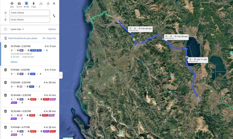
This means that to go from one city to another, you just need to search in Google Maps and the itinerary is automatically generated, in some cases with more than one option, depending on the destination you want to go to and the route you want to choose.
“The data that is currently on the Google Maps has as its source several operators, from e-Transport, which is the official website of intercity public transport in the country, the Municipality of Tirana regarding public transport in the capital, as well as private entities that have data platforms on transport,” wrote the “Monitor” magazine.
For example, if you want to go from Tirana to Korça, the map specifies the nearest urban bus to reach the center of the capital from where you then take the urban bus that leads you to the “Southeastern Terminal”. There you take the bus that takes you to Korça, which departs every 60 minutes, in this case.
Albania, with its growing interest as a tourist destination, has had to coordinate public transport on Google Maps, given that the options it offers are limited, focusing only at buses since functional railway lines are missing. /r.e//a.f/p.s./